KARL STEPHAN, Munich / Germany (1999)
******************************************************************
Model » NAVIMAT-501 «
Easy to get: o Distance
o Flight-Time
o Velocity-Over-Ground
o Course
o Calculating
- Velocity
- Luv-Angle
H O W T O U S E the S T E P H A N » NAVIMAT-501 «
=================================================================
Fig.[A] 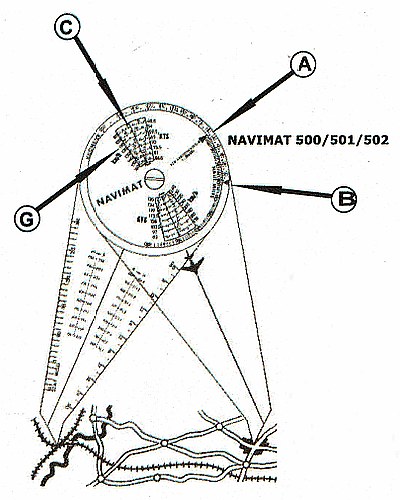 FRONT SIDE ...
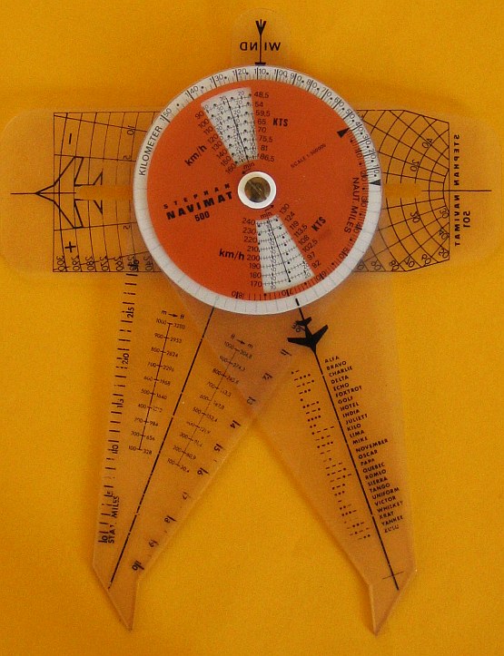
FLIGHT-TIME: Place the ACRYL-TIPS of the NAVIMAT to START
and GOAL on the MAP. Read DISTANCE in Kilometer on (A) or on
(B) Nautical Miles. Under (C), refering to your Velocity,
read FLIGHT-TIME.
VELOCITY-OVER-GROUND: Between 2 remarkable Points on
Ground, TAKE your FLIGHT-TIME. Set the ACRYL-TIPS of NAVIMAT
to this 2 Points on Map. Find with the TAKEN-FLIGHT-TIME your
VELOCITY-OVER-GROUND under (C).
Fig.[B]
FRONT SIDE ...
FLIGHT-TIME: Place the ACRYL-TIPS of the NAVIMAT to START
and GOAL on the MAP. Read DISTANCE in Kilometer on (A) or on
(B) Nautical Miles. Under (C), refering to your Velocity,
read FLIGHT-TIME.
VELOCITY-OVER-GROUND: Between 2 remarkable Points on
Ground, TAKE your FLIGHT-TIME. Set the ACRYL-TIPS of NAVIMAT
to this 2 Points on Map. Find with the TAKEN-FLIGHT-TIME your
VELOCITY-OVER-GROUND under (C).
Fig.[B] 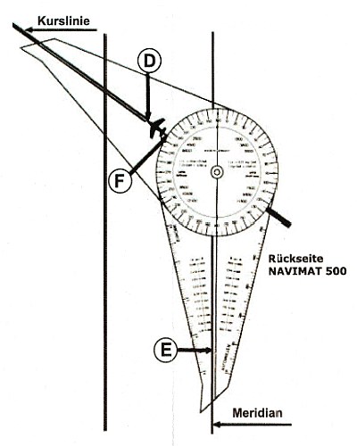 BACK SIDE ...
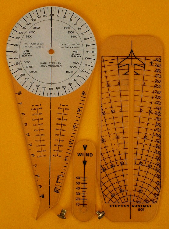
COURSE: Put the ACRYL-ANGLE with PLANE (D) so on the Map,
that the PLANE shows in the Course-Direction. TURN the OTHER
ACRYL-ANGLE so, that its MIDDLE-LINE (E) is PARALLEL to a
MAP's MEDIAN A N D the DEGREE-Figures are UPRIDE READABLE.
Read on (F) the COURSE.
Fig.[C]
BACK SIDE ...
COURSE: Put the ACRYL-ANGLE with PLANE (D) so on the Map,
that the PLANE shows in the Course-Direction. TURN the OTHER
ACRYL-ANGLE so, that its MIDDLE-LINE (E) is PARALLEL to a
MAP's MEDIAN A N D the DEGREE-Figures are UPRIDE READABLE.
Read on (F) the COURSE.
Fig.[C] 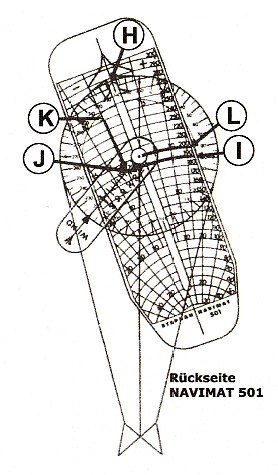 BACK SIDE ...
CALCULATION of VELOCITY-OVER-GROUND and LUV-ANGLE:
Place the ACRYL-DIAGRAM with the PLANE-SYMBOL (H) ON COURSE.
Place the WIND-ARROW-LAYER in WIND-DIRECTION. SLIDE the ACRYL-
DIAGRAM in the COURSE-DIRECTION so, that VELOCITY (I) comes
under the WIND-VELOCITY (J). Read on the same CROSS-POINT (K),
the LUV-ANGLE. Over the MIDDLE-POINT of NAVIMAT read (L), your
VELOCITY-OVER-GROUND.
-------------------------------------------------------------------
"THANKS!"
BACK SIDE ...
CALCULATION of VELOCITY-OVER-GROUND and LUV-ANGLE:
Place the ACRYL-DIAGRAM with the PLANE-SYMBOL (H) ON COURSE.
Place the WIND-ARROW-LAYER in WIND-DIRECTION. SLIDE the ACRYL-
DIAGRAM in the COURSE-DIRECTION so, that VELOCITY (I) comes
under the WIND-VELOCITY (J). Read on the same CROSS-POINT (K),
the LUV-ANGLE. Over the MIDDLE-POINT of NAVIMAT read (L), your
VELOCITY-OVER-GROUND.
-------------------------------------------------------------------
"THANKS!"  BERLIN
Kindly they send us the lost (German) Instruction to get here shown
DIAGRAMS - The TEXT-Translation to English is on my responsibility.
Historical Remarks ...
impressum:
*******************************************************************
© C.HAMANN http://public.BHT-Berlin.de/hamann 05/30/20 BERLIN
Kindly they send us the lost (German) Instruction to get here shown
DIAGRAMS - The TEXT-Translation to English is on my responsibility.
Historical Remarks ...
impressum:
*******************************************************************
© C.HAMANN http://public.BHT-Berlin.de/hamann 05/30/20
|